
Legal and Insurance Actionable Intelligence
Independent, time-stamped, and georeferenced reality capture for complex claims, forensic documentation, and litigation support.
The Challenge of Verifiable Data
High-value claims and legal disputes often drag on and cost more due to lacking objective, time-stamped baseline data. Claims managers and adjusters rely on subjective assessments or incomplete photos that are easily contested, complicating liability determination and accurate damage assessment.Post-incident forensic investigations face major safety and access issues, especially in hazardous or structurally compromised sites. Sending personnel into affected or confined spaces is risky and delays crucial initial data capture for accurate loss adjustment. Traditional inspection methods are slow, allowing critical information to degrade or be altered before it’s documented.Legal teams and expert witnesses need highly accurate, legally defensible, and independent data. Inconsistent methods or poor spatial referencing can weaken evidence. The key is engineering‑grade, irrefutable spatial data that serves as a single source of truth for all parties and is understandable to both laypeople and technical experts.Independent Reality Capture, Documentation and Baseline Intelligence
DeepSky IQ provides irrefutable, engineering-grade spatial data acquisition to support inspections, condition reporting, complex insurance claims and litigation. Our independent asset intelligence delivers the definitive datasets required by loss adjusters, litigation teams, and insurers to resolve disputes efficiently and accurately.Core Capabilities:
Pre-Damage or Pre-Policy Baseline Capture:
We establish comprehensive digital records of asset condition prior to incidents or, for high-value or high-risk assets, prior to policy approvals, providing an objective benchmark for future claims and risk assessment.
Post-Incident Reality Capture Documentation:
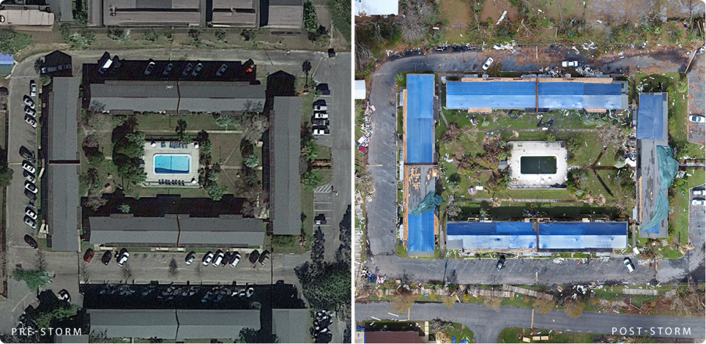
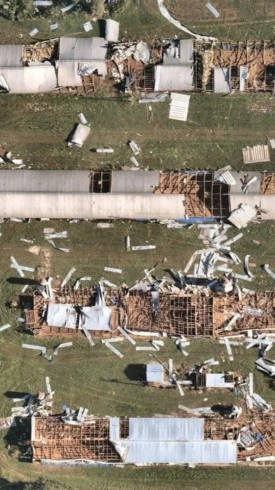
Rapid deployment of multi-sensor capture technology to secure high-resolution, georeferenced evidence immediately following a loss event, before site degradation occurs.Independent Condition Evidence:
Delivery of unbiased, time-stamped spatial data that serves as a definitive single source of truth, eliminating subjectivity from the claims adjustment process.Expert Witness Support:
Provision of rigorous, engineering-grade data sets and 3D models that are fully defensible in court, supporting expert testimony, clear communication, immersive context capture and legal strategy.Hazardous Environment Access:
Utilisation of our enterprise capture fleet to safely acquire critical evidence from structurally compromised buildings, confined spaces, and hazardous disaster zones without risking human life.
What We Can Do
From condition reports, 3D scene reconstructions to digital twins, with mm-levels of georefrenced detail for engineering-grade models and stakeholder confidence.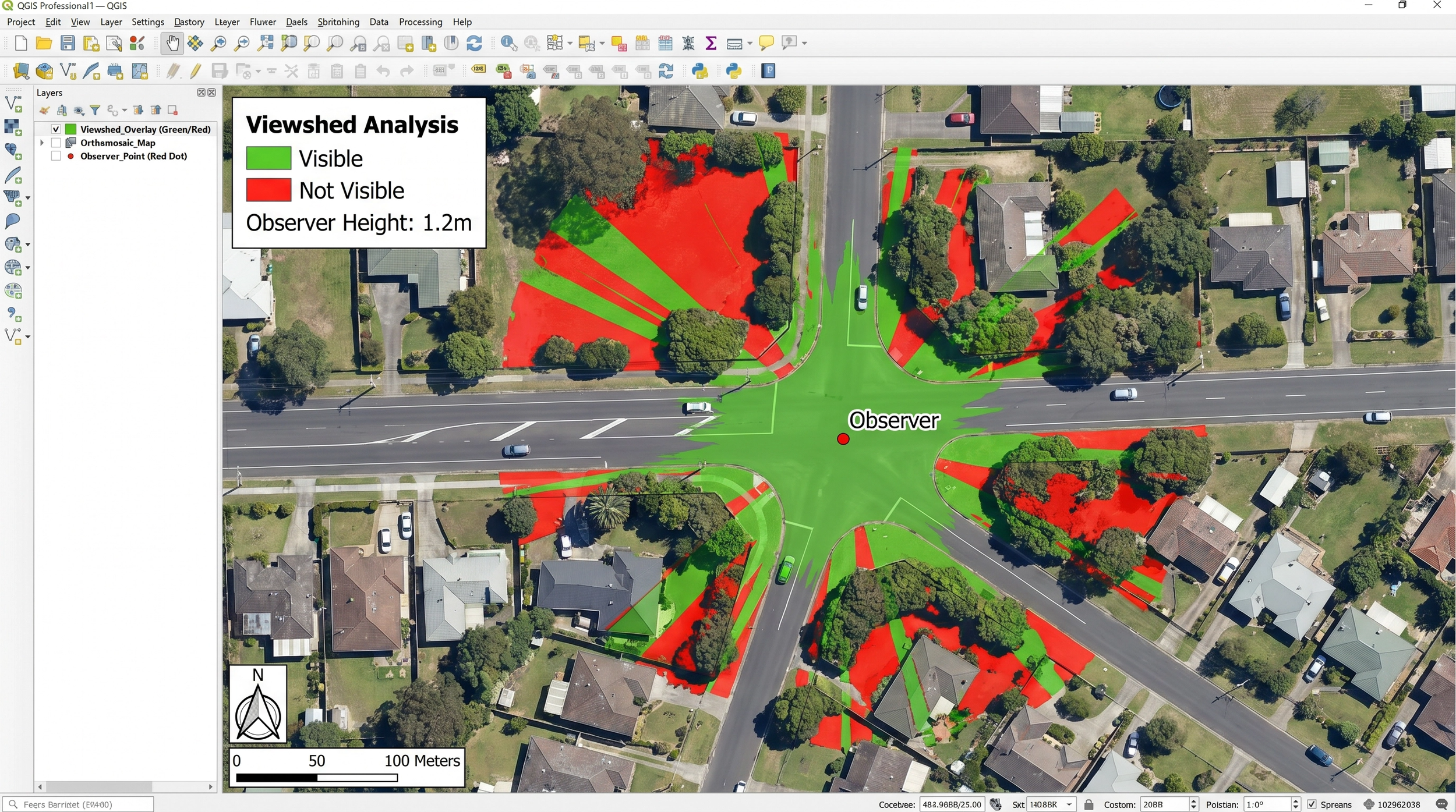
-
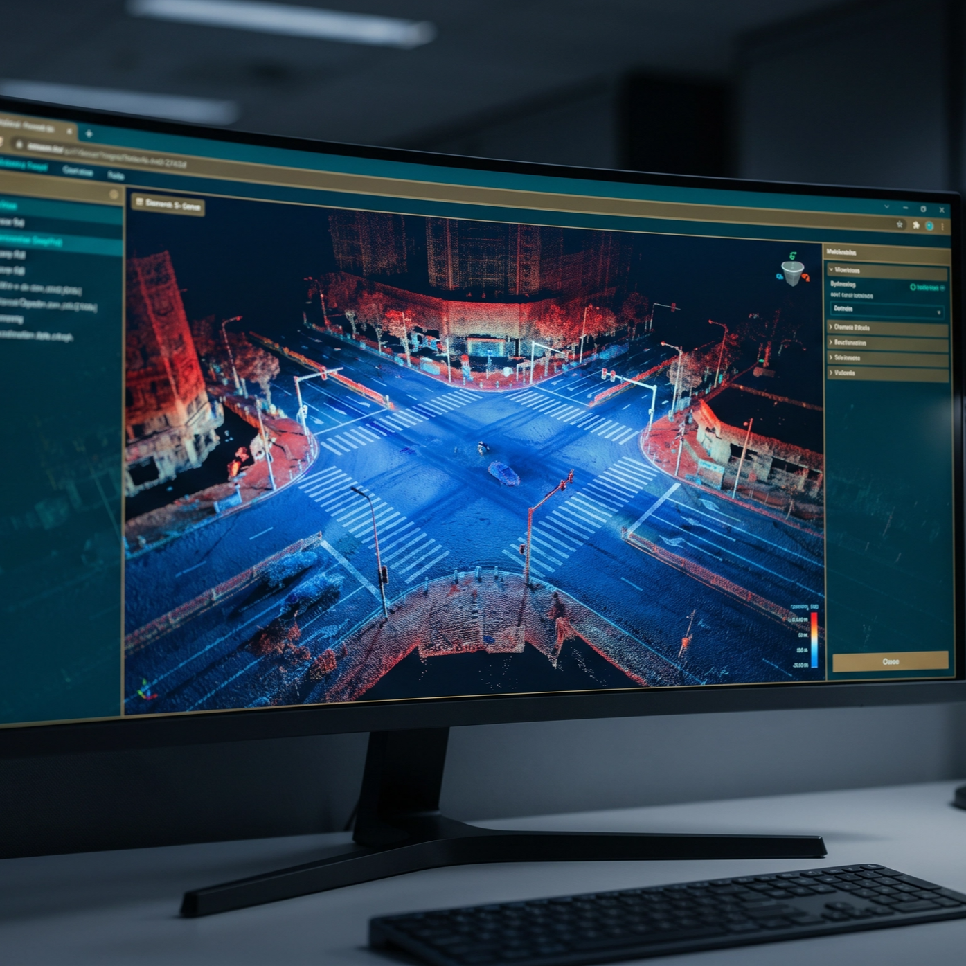
DeepSky IQ creates high fidelity 3D digital twins through reality capture to provide clear, objective representations of locations, infrastructure, assets and incident scenes.
These models replicate conditions with precision, helping legal teams illustrate complex scenarios, demonstrate impact and support testimony.Accurate interactive visuals. Better communication, Stronger arguments. Clearer outcomes.
-
Our 3D models and condition reports help insurers assess damage, quantify loss and validate claims with objective, evidence backed data to reduce fraud and improve services.
The result is faster reality capture & assessment, improved processing & communication to reduce dispute potential and stronger confidence in the claims process by both the client and the insurer.
-
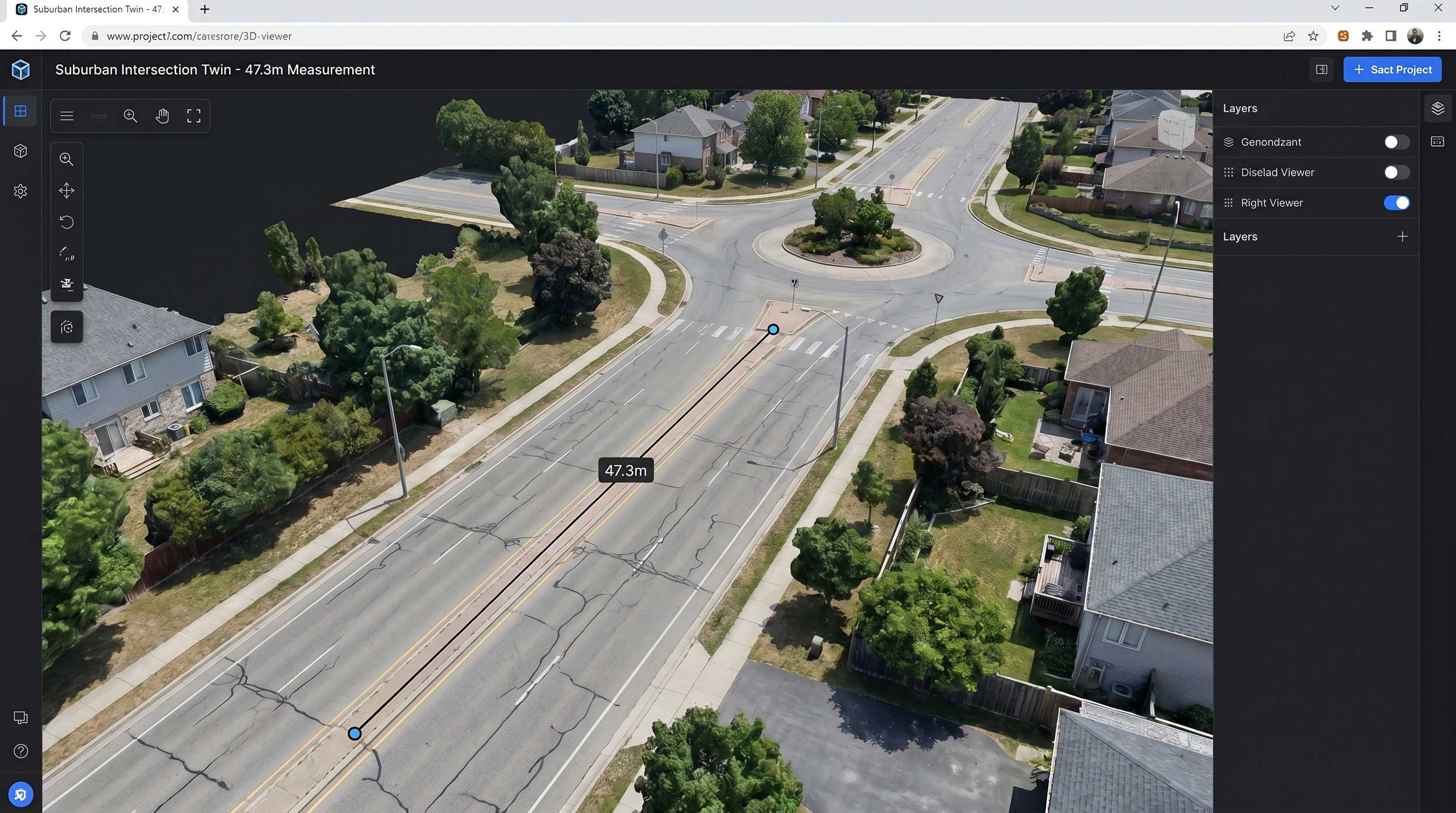
Our scene or site reconstruction as 3D interactive Digital Twin captures the sub centimetre details safely and georeferenced accurately without disturbing evidence or with unnecessary delays.
Every scan is timestamped, geolocated and processed into a secure, defensible dataset for long term reference. Coupled with our high fidelity software to take you back to the day and time, day or night, lighting and light distribution or degree of darkness, viewshed analysis, signage, markings, vegetation obstructions, POV and even shadows as they were then.
One interactive, contextualised model, accessible for expert measurements without the delays, without the discrepancies.
This supports investigations, loss adjusters, government services and multidisciplinary legal teams.
The Financial Impact
The Australian insurance landscape is facing unprecedented challenges, with $4.8 billion in insured losses resulting from 294,000 claims in 2025 alone (ICA, 2026).
In this high-volume, high-stakes environment, implementing premium asset intelligence programs delivers substantial returns on investment through accelerated claim resolution, fraud reduction and mitigated litigation risks.
Faster, Remote Assessments:
Adjusters can use 3D models and high-resolution images to view property damage remotely, minimising site visits and accelerating claim settlements. A 3D digital replica of the damage removes the need to rely on potentially exaggerated or false manual inspection reports, allowing for accurate, objective assessment.Enhanced Fraud Detection:
By comparing digital twins of a damaged asset (like a car or home) against the claimed incident, insurers can identify discrepancies, simulate accidents, and reduce fraudulent payouts with some studies showing a 54.8% increase in detected claim errors. High-resolution imagery before a policy is issued or before a natural disaster occurs creates a "digital source of truth" (a digital twin), which prevents customers from claiming that pre-existing damage was caused by a new event.Accurate Documentation:
Digital twins provide time-stamped, comprehensive records of property conditions before and after an event, creating "defensible evidence" for contested claims and enabling easy, interactive comparison overlays.Improved Risk Mitigation:
Insurers use virtual 3D models to detect prior issues, such as using drones with thermal sensors to detect water under a tiled roof that may not be disclosed and could trigger a payout. Predicting damage from environmental events using baseline digital twins allows forensic recreation of accidents or structural failures, enabling insurers to model whether damage is consistent with the claimed cause, support proactive risk management, and reduce future loss claims.$4.8b
in losses (2025)
Total insured losses from 294,000 claims in Australia during 2025, highlighting the critical need for accurate loss adjustment - Insurance Council of Australia (ICA). (2026)
45%
Reduction in False Claims
By detecting pre-existing damage, verifying claims instantly, and preventing false reporting - InsurTech, 2022
90%
Reduction in Risk
Up to 90 percent reduction in cost and risk when accessing confined spaces for post-incident documentation - Flyability & Multinnov. (2025)
70 - 85%
Cost Reduction
Achieved in tank and vessel inspections alone, compared to traditional scaffolding methods, significantly lowering the cost of forensic data acquisition - Struction Solutions. (2025)
40 - 60%
Improvement in data
Enhancement in defect detection accuracy utilising multi-sensor capture technology, ensuring no critical evidence is overlooked - Irizarry, J., & Costa, D. B. (2016)
Integrated Services
Create exact, interactive digital replicas of assets & incident sites for immersive insights, presentations and remote loss adjustment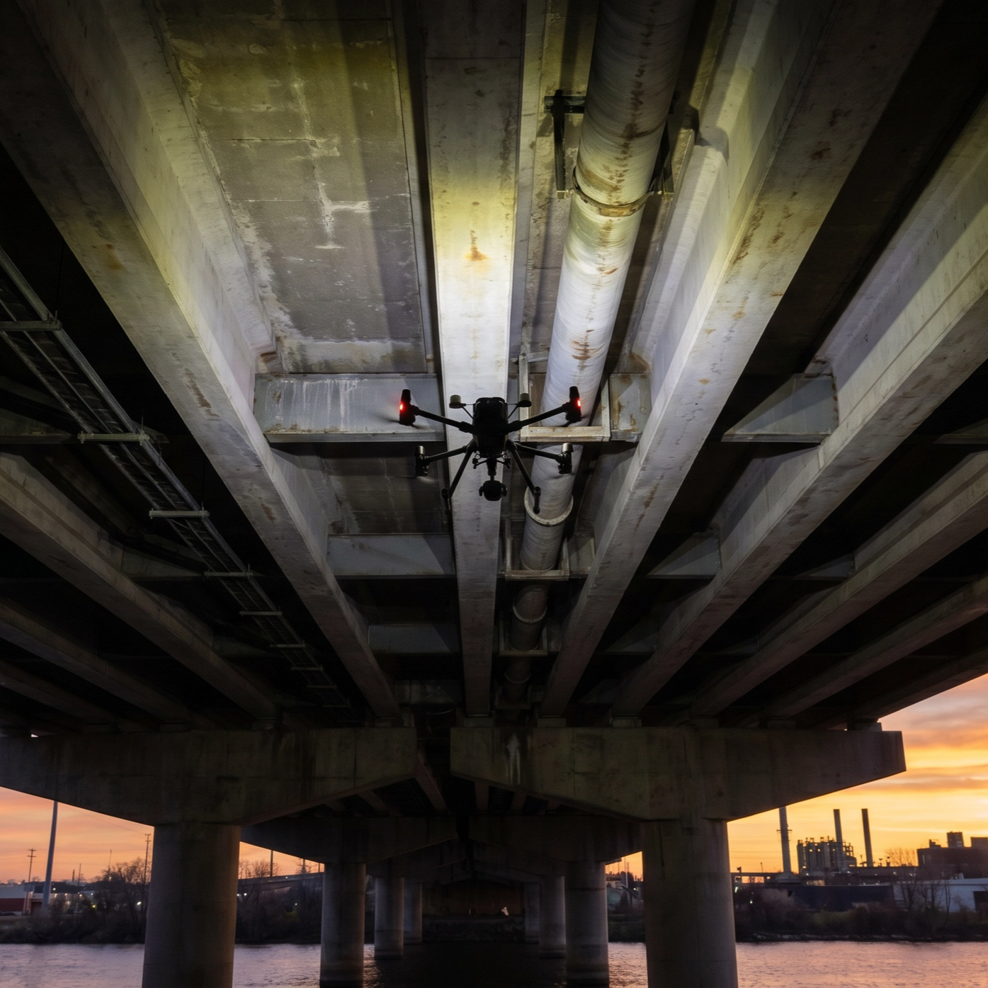
Rapid, 360 degree high-resolution documentation of condition, damage or claim following natural disasters or asset failures. 
Detect hidden moisture intrusion, electrical faults, and structural anomalies critical to determining the root cause of a loss.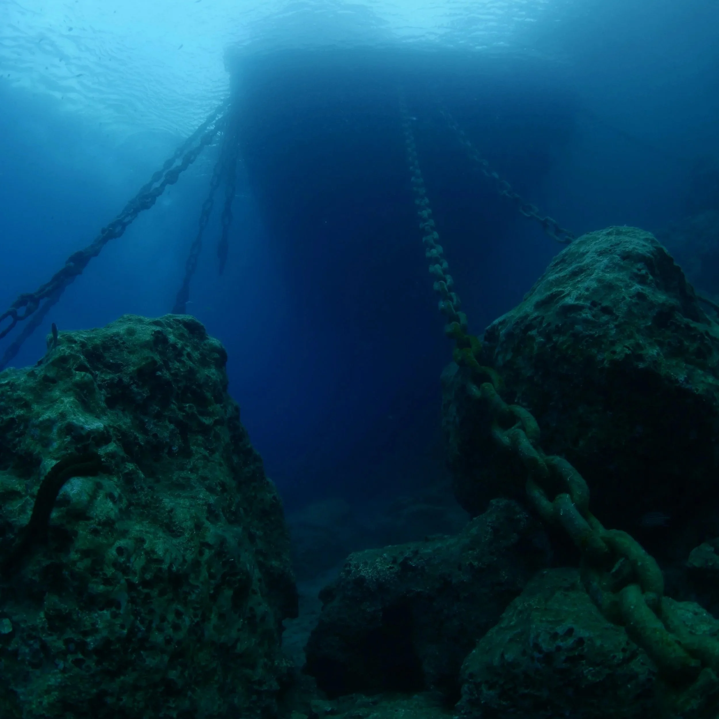
Secure vital information from above and below the surface, from submerged infrastructure, marine vessels, ports, marinas and flooded environments safely and efficiently.Frequently Asked Questions
How does DeepSky IQ ensure the data captured is defensible?
We ensure defensibility by employing rigorous, engineering-grade capture methodologies. All spatial data is precisely georeferenced, captured using a variety of RTK/PPK capabilities, time-stamped, and accompanied by a secure chain of custody. Our independent status ensures the intelligence we provide is objective and unbiased, making it highly reliable for expert witness testimony and litigation support.Can your data capture platforms safely access structurally compromised buildings?
Yes. Deploying personnel into compromised structures is highly dangerous and costly. We utilise our enterprise data capture fleet, including robotics, specialised confined space platforms and aerial systems, to evidence-grade data, safely and rapidly,navigate hazardous environments remotely. This allows us to acquire critical evidence-grade data, safely and rapidly, without exposing personnel to unacceptable risks.What is the typical investment for a forensic grade asset intelligence program?
Can you provide expert witness support for disputes?
For enterprise clients, insurers, and major legal firms, our comprehensive asset intelligence programs typically range from $5,000 to $150,000+, depending on the scale, complexity, and frequency of the required data acquisition or engagements. This investment is offset by reduced protracted litigation, faster claim resolution, lower fraud, and the elimination of traditional, high-cost inspection methods.How quickly can DeepSky IQ deploy following a major loss event?
What types of insurance claims does drone and ROV data support?
How does drone inspection data reduce litigation costs?
We know time is critical after a major incident to prevent evidence degradation and speed up claim processing. DeepSky IQ can deploy quickly across Australia for ongoing clients or urgent activations. We can mobilise our teams by air or road to secure the site digitally and capture high-resolution baseline data before any physical remediation or clearing work begins. Importantly, our advanced software allows us to recreate the conditions at the time of the event.Our engineering-grade data supports property damage claims, construction defect disputes, natural disaster assessments, fire damage quantification, flood impact documentation, subsidence claims, and marine infrastructure damage. We capture forensic-quality evidence, including millimetre-accurate 3D models, thermal anomaly mapping, and time-stamped condition records. For insurers, our independent data accelerates claim validation by 40-60% and reduces fraudulent claims through objective, measurable documentation that cannot be disputed. We have supported claims ranging from $50,000 in residential losses to $50M+ in commercial and infrastructure losses.Independent, engineering-grade spatial data reduces litigation costs by providing objective, measurable evidence that accelerates dispute resolution. Traditional building disputes average 18-24 months and $150,000-$500,000 in legal costs. Our forensic-quality digital twins and condition reports provide irrefutable evidence that often resolves disputes at mediation rather than trial. The data is time-stamped, georeferenced, and captured under ISO 9001 quality management systems, making it highly defensible as expert evidence. Typical ROI for legal firms is 5-10x the cost of the data capture engagement.Yes. Our data capture methodology is designed to produce court-admissible evidence. We provide structured condition reports with chain-of-custody documentation, georeferenced measurements accurate to +/-2cm, and 3D digital twins that allow remote technical expert review. Our independence as a third-party data provider (not engaged by either party in the dispute) strengthens evidential weight. We can support expert witnesses with interactive 3D models, before-and-after comparisons, and measurement verification that simplifies complex technical evidence for non-technical decision makers.